Airmate 3.15
Continue to app
Free Version
Publisher Description

Now with real time traffic!
Airmate is a free and easy to use flight planning and weather app for pilots, improving situational awareness and providing instant access to airport data and aviation maps, up to date weather and NOTAMs, traffic around.
IFR and VFR airport plates are freely available in US (FAA charts), Europe, and more than 200 other countries. Many of them are georeferenced and could be overlaid on the aviation chart. A powerful Plate Manager allows to download in advance all airport plates in a country, they could be easily printed and viewed.
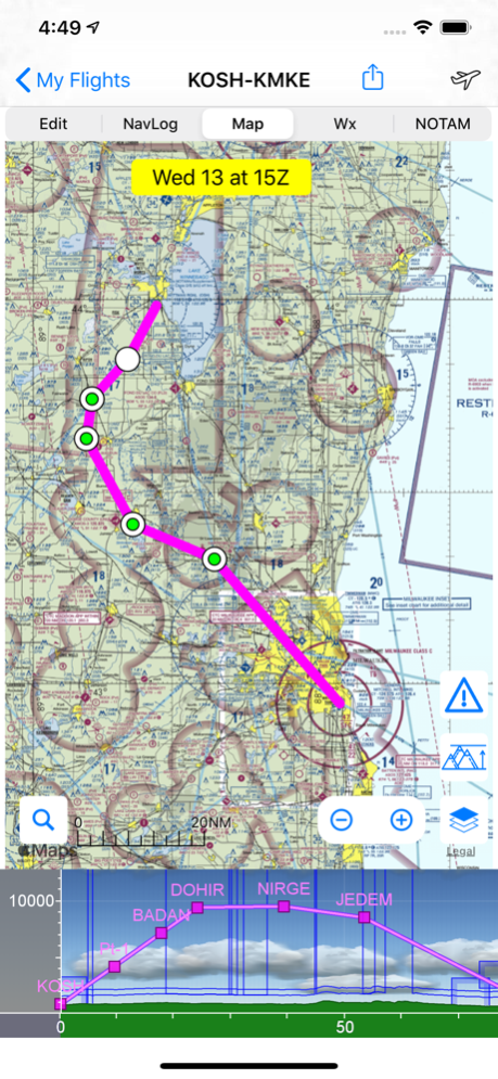
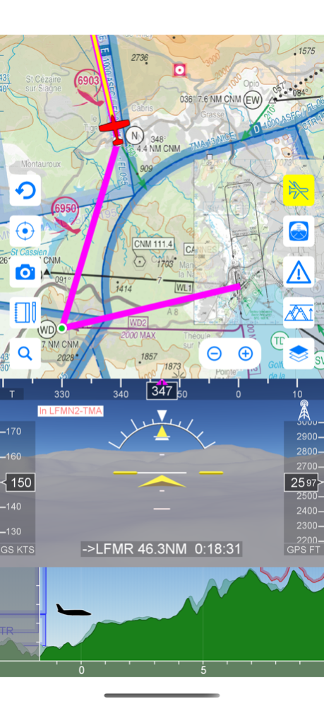
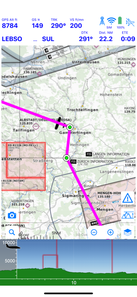
During the flight, the moving map will display the aircraft location along the route, show airports and aeronautical data details and traffic around, warn you if your planned route is crossing restricted areas. A profile view is available to display terrain elevation, crossed areas and forecasted weather across the route. Airmate can also display a backup aircraft attitude indicator and flight parameters in an EFIS-like view. In the whole world, Synthetic Vision displaying in the EFIS-like view the ups and downs of rolling terrain ahead is available. In selected countries, Airmate can display scenery if this option is purchased.
Airmate includes a worldwide aeronautical database updated free of charge with airports, navigation beacons, waypoints, airways, obstacles, regulated and restricted areas. Topographic maps and elevation data for most countries may be downloaded free of charge, as well as additional aviation map overlays such US Sectionals. A procedure database provide details of departure (SID), arrival (STAR) and instrument approaches in the USA, and you could add those procedures to your planned flight route (the procedure database includes all US airports, we are workding to add airports in other countries). Once loaded, the procedure path is displayed on the aeronautical map, including curved paths and racetracks.
When coupled with a supported external ADS-B received, Airmate will display nearby traffic on the moving map, and receive FIS-B weather and NOTAM during the flight. To improve safety, Airmate can display neighbouring traffic received over mobile network. Such traffic include commercial airlines and transponder-equiped aircrafts, FLARM gliders, aircrafts whose pilots are using Airmate and other users using other safety broadcasting equipment.
Airmate is able to transmit the flight plan data to supported avionics such Dynon SkyView.
Thanks to the Auto Route feature, you could search and select the best route for your flight, and then file your VFR or IFR flight plan. Once filed, your flight plan could easily be managed, delayed or cancelled.
Airmate will also record your flights and allow to replay them later or export the flight path in gpx format, you could take pictures from the app during flights. Pilot log entries are automatically computed from flown flights.
A Satellite map display mode in flight planning or replay mode allows to familiarize with significant landmarks.
Airmate will save planned and flown flights, user waypoints and user aircrafts in the cloud and sync them between your devices and Airmate web flight planning.
Airmate brings social features to the community. Pilots may leave ratings, tips and comments to share their experience with fellow pilots, and report fuel prices and handling fees. They could find friends, instructors, flight schools, aviation events and aircraft to rent near their home airport or any visited airport. A planned flight may be shared with other pilots by indicating the number of seats available for additional passengers.
Airmate may be connected to most flight simulators to keep flying skills sharp, and will manage also AHRS and simulated traffic data transmitted by the flight simulator. Planned flights and personal waypoints may be imported and exported.
Continued use of GPS running in the background can dramatically decrease battery life.
Terms of Use: https://www.apple.com/legal/internet-services/itunes/dev/stdeula/
Apr 16, 2024
Version 3.15
Update fixing a plate download failure for the first operation and including previous version improvements:
- Download of airport diagrams and approach plates for a whole country now done with a country package with additional integrity checks.
- Real time position sharing with other Airmate users may be enabled or disabled from the layers button (disabled by default for privacy)
- Improved mapping controls, with the ability to switch anytime between map vector, raster and Satellite views
- Increased zooming capability on the Satellite view
- Improved display of nearby traffic received either over the mobile network (no equipment needed) or a supported ADS-B receiver or avionics.
- Improvement in the traffic warning window showing potential conflicting traffic (informational only, Airmate is not an approved collision avoidance device, and the pilot-in-command remains the only responsible for collision avoidance).
- Traffic received from mobile network or a connected hardware receiver may be forwarded to other apps (Airmate Premium required)
- Improved display for Flight Information Sectors (FIS)
- Fix a loading issue for some IFR approaches where legs may be loaded in duplicate.
- Fix an issue in the downloading of Airmate data for Dynon SkyView USB drive programming affecting subscribers in the USA region
- Thousands of Airmate airport diagrams now available in the USA for airfields without FAA diagrams (for information only).
- Fix display issues on iPhone 14 and 15 devices
- Fix an issue in the Airmate Pro option management that was sometimes incorrectly disabled, conversion of Airmate Pro to Airmate Premium.
- Miscellaneous other improvements.
- Fix various other issues and crashes.
- Include a worldwide aeronautical database at cycle 2404 (April 18th, 2024), automatically updated
About Airmate
Airmate is a free app for iOS published in the Recreation list of apps, part of Home & Hobby.
The company that develops Airmate is Myriel Aviation SA. The latest version released by its developer is 3.15.
To install Airmate on your iOS device, just click the green Continue To App button above to start the installation process. The app is listed on our website since 2024-04-16 and was downloaded 16 times. We have already checked if the download link is safe, however for your own protection we recommend that you scan the downloaded app with your antivirus. Your antivirus may detect the Airmate as malware if the download link is broken.
How to install Airmate on your iOS device:
- Click on the Continue To App button on our website. This will redirect you to the App Store.
- Once the Airmate is shown in the iTunes listing of your iOS device, you can start its download and installation. Tap on the GET button to the right of the app to start downloading it.
- If you are not logged-in the iOS appstore app, you'll be prompted for your your Apple ID and/or password.
- After Airmate is downloaded, you'll see an INSTALL button to the right. Tap on it to start the actual installation of the iOS app.
- Once installation is finished you can tap on the OPEN button to start it. Its icon will also be added to your device home screen.
